7 October 2014
Italian Limes is a research project and installation presented at the 14th International Architecture Exhibition in Venice, which opened on June 7 and can be visited until November 23. This post is the second in a series of analyses that will set out to expand on the themes of research that underpin the project over the coming months, outlining possible developments and presenting new material not included in the exhibition.
“In [The Glacier Series], the massive glaciers are seen from the sky, at a distance where we can appreciate their magnitude; in order to see them in their entirety, we need to get away from them. Their incremental movement is a phenomenon we understand by the virtue of scientific knowledge, not of what we can see with the naked eye.” (Matthew Drutt, “Olafur Eliasson: A Cultivated View,” in Olafur Eliasson: Photographs, 2004, p. 13).
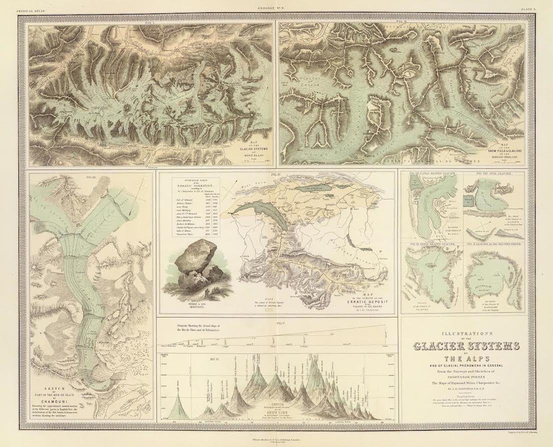
Rappresentazioni dei ghiacciai alpini e dei fenomeni glaciali in generale, tratte dai rilievi e disegni del Prof. Forbes e dalle mappe di Raymond, Weiss, Charpentier & C.”, incisione di W. e A.K. Johnston, William Blackwood & Sons, Edinburgo e Londra, 1854. Courtesy of David Rumsey Map Collection. / Illustrations of the glacier systems of the Alps and of glacial phenomena in general. From the surveys and sketches of Professor Forbes, the maps of Raymond, Weiss, Charpentier & C.”, engraved by W. and A.K. Johnston, William Blackwood & Sons, Edinburgh & London, 1854. Courtesy of David Rumsey Map Collection.
The movement of a glacier is something that can only be deduced from observation of its consequences, from the effects that it produces on its surroundings in the process of its imperceptible but continuous downhill flow. The surface of a glacier is the formal result of this transformation, as if it were a high-resolution still of a flow in which the extremely high viscosity of the fluid produces the effect of a video shot at a rate of just a few frames a year. Crevasses—fractures caused by the friction between the blanket of ice and the irregularities of the rocky surface underneath—are the most obvious feature. Another is provided by the typical parallelism of the medial moraines that are created when ice from more than one basin flows into the bed of a single glacier.
A glacier is called “dead” when it stops moving: in the majority of cases this happens as a result of its thinning and of the consequent emergence of the rock underneath, which breaks up and separates the sheet of ice, preventing it from maintaining sufficient mass to overcome friction and continue to flow downward. A dead glacier is progressively buried by stones and debris, creating an unreal and desolate landscape. This type of landscape, along with glacial valleys at an altitude that does not permit the growth of vegetation on the surfaces left free by the retreat of the moraines, is becoming increasingly common on the ridge of the Alps that marks the border between Italy, Austria and Switzerland.
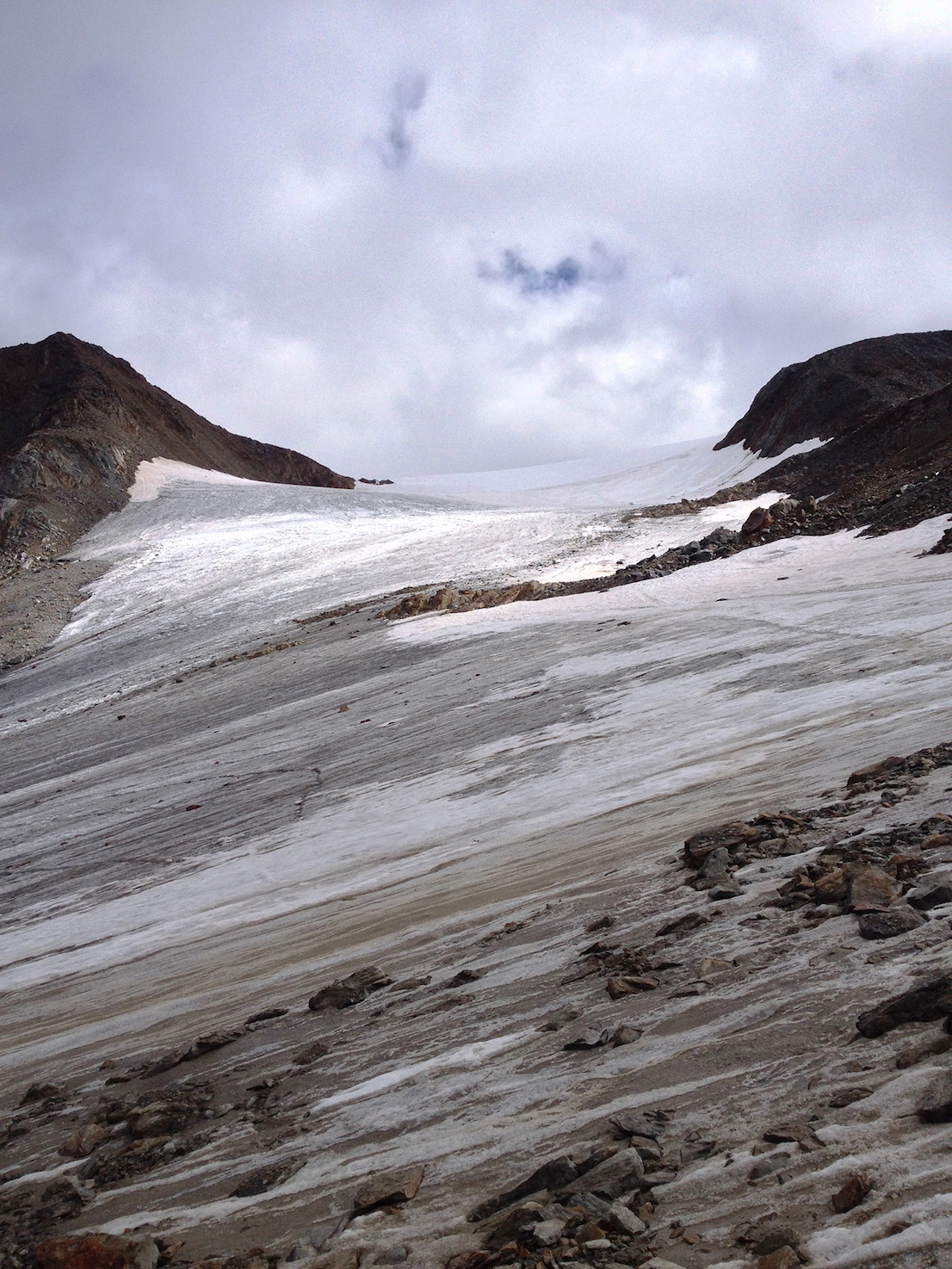
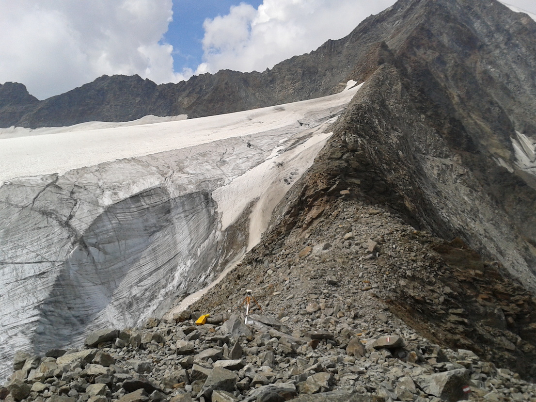
La Vedretta del Giogo Basso lungo la via normale di salita al Similaun, 21 settembre 2014. / The cirque glacier known as the Vedretta del Giogo Basso on the normal route of ascent of the Similaun, September 21, 2014.
Since the middle of the 19th century, the mass of ice on the five continents where glaciers are present has shrunk enormously. The speed of this retreat tripled in the period between the 1970s and the beginning of the 21st century. Over the course of just one summer, in 2003, the total loss of volume of the glaciers in the Alps approached 10% of the entire remaining mass. Although documentaries like Chasing Ice, made by the American photographer James Balog, have recorded the dramatic rate at which the Arctic icecap is melting, it is in fact the Alpine glaciers that are being most affected by climate change. Unlike the vast glacial systems of the Himalayas or Patagonia, for example, the relatively small size of the Alpine ones means that they are unable to moderate the imbalance of their mass resulting from the increase in temperature.
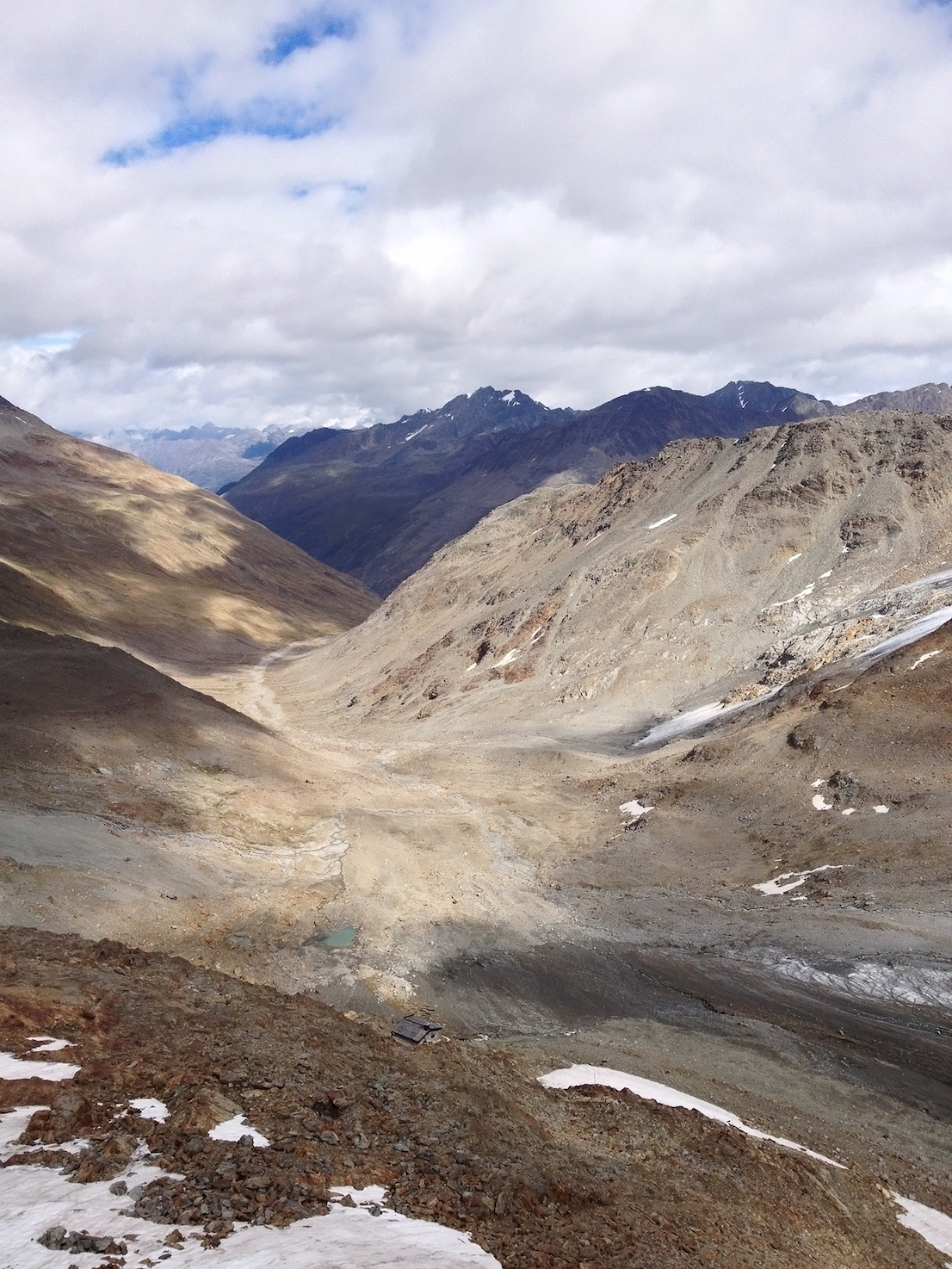
Il letto del ghiacciaio del Similaun (Niederjoch Ferner) oramai vuoto, 21 settembre 2014. / The now empty bed of the Similaun glacier (Niederjochferner), September 21, 2014.
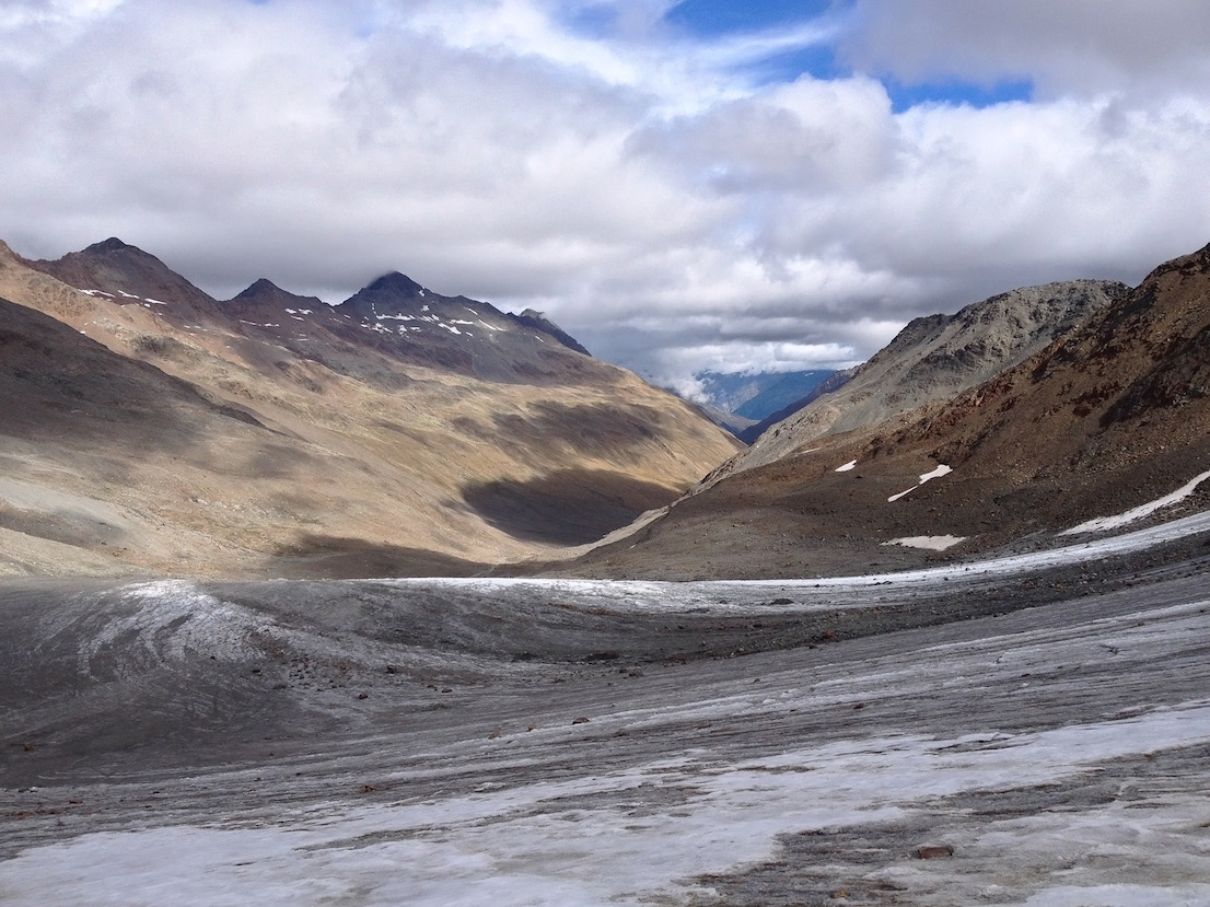
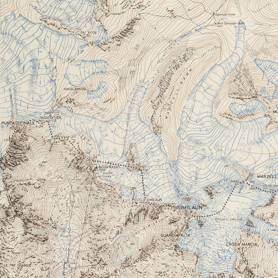
Vista del letto del ghiacciaio del Similaun dai pressi del Passo di Tisa, verso l’Austria, 21 settembre 2014. Le due lingue del Niederjoch Ferner (in basso a destra) e del Marzell Ferner (in alto a destra), precedentemente unite in un unico ghiacciaio, hanno subito un ritiro tale da renderle oramai completamente separate. / View of the bed of the Similaun glacier from the vicinity of the Tisa Pass leading to Austria, September 21, 2014. The two tongues of the Niederjochferner (bottom right) and Marzellferner (top right), previously united in a single glacier, have retreated so far that they are now completely separate.
At present, around 150 Italian glaciers are being monitored as a study sample by the Comitato Glaciologico Italiano, which has been responsible since 1911 for systematically surveying variations in glacial fronts on the national territory. In 1927, the first Atlante dei Ghiacciai Italiani [“Atlas of Italian Glaciers”] was published in collaboration with the Istituto Geografico Militare, in which all the Italian ice sheets present in the Alps and Apennines were represented on a scale of 1:500 000. The indexing and representation of these areas at high altitude make it possible to define with precision the line of the watershed along the arc of the Alps, which constitutes the natural element through which the presence of the State border is revealed on the territory, and long sections of which run across perennial ice sheets. In fact, the entire northern frontier of Italy is a line traced through an archipelago of glaciers. Hard to see on paper, the reason for the association between the tracing of the border and the line of the watershed becomes evident when you look at the morphology of the terrain in the field, where catchment basins covering thousands of square kilometers define their own boundaries but without communicating with one another.
As a consequence of the progressive retreat of the glaciers, the Alpine watershed has undergone considerable displacements in recent years, making it necessary to renegotiate the terms of the boundary between Italy and the adjoining states. The shift in the line of the watershed can take place both in altitude (when a glacier thins or disappears, allowing the emergence of the ridge of rock underneath, which therefore becomes the new and definitive dividing line), and ?on the surface? (slippage and retreat of the glacial basins that result in a modification of its course). Since 2008, the Istituto Geografico Militare has been carrying out campaigns at high altitude every two years to detect any (irregular and unpredictable) shift in the borderline and update the official maps. The possibility of assessing the scale of such changes is provided by the extremely high resolution of GPS measuring instruments, whose subcentimeter accuracy equals that of the permanent stations of the transnational GAIN (Geodetic Alpine Integrated Network) for the measurement of tectonic motions and seismic activity throughout the Alpine arc.
Confine di Stato italo-austriaco, campagna di determinazione del confine mobile sui ghiacciai dell’Alto Adige da parte dell’Istituto Geografico Militare. È visibile il ghiacciaio Ubelalferner, nei pressi del Rifugio Cima Libera, a quota 3.160 m, che ritirandosi ha fatto emergere la cresta rocciosa sottostante che individua l’attuale Confine di Stato. Foto di Simone Bartolini, agosto 2012. / Austrian-Italian border, campaign of determination of the mobile border on the glaciers of South Tyrol by the Istituto Geografico Militare. The picture shows the Ubelalferner glacier, in the vicinity of the Cima Libera Refuge, at an altitude of 3160 m, whose retreat has uncovered the ridge of rock beneath that marks the current state boundary. Photo by Simone Bartolini, August 2012.
The introduction of the concept of a “mobile border”—apart from the small adjustments of the boundary line made in the second half of the last century—has been, in fact, the only substantial modification to the State border since the end of the Second World War. Fortunately, unlike other parts of the planet where similar dynamics are underway (in the Campo de Hielo Patagónico Sur, on the border between Chile and Argentina, or in the Siachen Glacier spanning the area between India, China and Pakistan, or, more recently, in the Arctic), the friendly relations between Italy, Austria and Switzerland have prevented the emergence of disputes, providing a model for the theoretical and practical solution of problems of this kind. However, the enormous geopolitical importance of the ice-covered regions—making up around 10% of the planet’s land surface and constituting huge reserves of fresh water—is destined to increase exponentially with the consequences of climate change. Inaccessible and previously marginal areas are today the subject of bitter territorial disputes between national states, determined to exploit new natural resources and increase their influence over neighboring regions. Within this scenario, the geographical and legislative notion of natural boundary—apparently explicit and objective—is being modified, reinterpreted and rewritten, making clear the political dimension and impermanent nature of any act of representation and definition of reality.
Estratto della tavoletta 3-II-NE “Cime Nere”, edizione 1970 (dai tipi dell’Istituto Geografico Militare). / Excerpt from plate 3-II-NE “Cime Nere,” 1970 edition (published by the Istituto Geografico Militare).
Colophon
Italian Limes is a project curated by Folder (Marco Ferrari, Elisa Pasqual) with Pietro Leoni (interaction design), Delfino Sisto Legnani (photography), Dawid Górny, Alex Rothera, Angelo Semeraro (projection mapping), Alessandro Mason (coordination of production) and Claudia Mainardi.
Italian Limes has received a Special Mention as a research project in the Monditalia section from the jury of the 14th Venice Biennale of Architecture.
Follow Italian Limes on Twitter.